
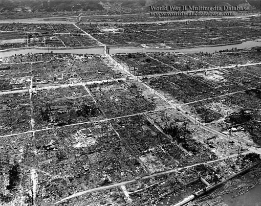
| The (top to bottom) Koi, Tsukishima, and Tenma tributaries of the Ota River (Japanese: “Ota Gama“) frame the devastation of Hiroshima looking West to Koi Station. The city is located on the broad fan-shaped delta of the Ota River, whose seven mouths (today six) divide the city into six islands which project fingerlike into Hiroshima Bay of the Inland Sea. These mouths of the river furnished excellent firebreaks in a city that is otherwise flat and only slightly above sea level. A highly developed bridge system, with 81 major bridges, joined the islands. A single kidney shaped hill in the eastern part of the city, about one-half mile long and rising to an elevation of 221 feet, offered some blast protection to structures on the eastern side opposite the point of fall of the bomb. Otherwise, the city was uniformly exposed to the spreading energy from the bomb. Because of the flat terrain and circular shape of the city, Hiroshima was uniformly and extensively devastated. Practically the entire densely or moderately built-up portion of the city was leveled by blast and swept by fire. A firestorm developed in Hiroshima: fires springing up almost simultaneously over the wide flat area around the center of the city drew in air from all directions. The inrush of air easily overcame the natural ground wind, which had a velocity of only about 5 miles per hour. The “fire-wind“ attained a maximum velocity of 30 to 40 miles per hour for hours. The “fire-wind“ and the symmetry of the built-up center of the city gave a roughly circular shape to the 4.4 square miles which were almost completely burned out. The surprise of the attack, the collapse of many buildings, and the conflagration contributed to an unprecedented casualty rate. Seventy to eighty thousand people were killed, or missing and presumed dead, and an equal number were injured. The magnitude of casualties is set in relief by a comparison with the Tokyo fire raid of 9-10 March 1945, in which, though nearly 16 square miles were destroyed, the number killed was no larger, and fewer people were injured. | |
| Image Filename | wwii1090.jpg |
| Image Size | 158.37 KB |
| Image Dimensions | 510 x 403 |
| Photographer | Unknown |
| Photographer Title | |
| Caption Author | Jason McDonald |
| Date Photographed | September 05, 1945 |
| Location | Ota River Tributaries |
| City | Hiroshima |
| State or Province | Hiroshima Prefecture |
| Country | Japan |
| Archive | |
| Record Number | |
| Status | Caption ©2007, ©2024 MFA Productions LLC Please Do Not Duplicate or Distribute Without Permission |

Author of the World War II Multimedia Database